|
On Lakeshore Dr. at St. Bernard Ave. in New Orleans where the lake meets Bayou
St. John is an historical marker which reads:
"Lake Pontchartrain
Traveled on by Iberville, 1699 and named for the French minister of Marine.
Indians called it Okwa-ta, wide water. First port of embarkation was at the site where bayou St. John flows from this
lake. It was the first water route to the city of New Orleans."
Although historically correct, that marker while crediting Native Americans for having first named Lake Pontchartrain
fails to include their contribution to the founding of the city of New Orleans. It was native tribespeople who showed
Europeans their age old route from the lake, down the bayou, along a natural high ridge, and finally to the Mississippi River.
Travelling down the bayou, not far past the
beautiful copper dome of Our Lady of the Rosary church one comes upon another marker.
This one describes the ridge and credits the first inhabitants for having revealed it to the French founder
of New Orleans:
"The Old Portage
Short trail from Lake Pontchartrain to river shown by Indians to Iberville and Bienville, 1699. Winding
trail used by early travelers to city. From Bayou St. John it lead to N. Broad, Bayou Road, Vieux CarrÈ to Mississippi River
at site between Dumaine and Gov. Nicholls Streets."
John Chase, in Frenchman, Desire, Good Children (and other streets of New Orleans) tells us that the portage
consisted of Grand Route St. John which merged into Bayou Rd. and then to the river.
In any case, the portage -- a geological build up of above sea level land that elluded the seasonal flooding of the river
was an important component in the settling of the city of New Orleans.
Further down the bayou one comes upon another marker, where City Park Ave. becomes W. Moss
St. and N. Carrollton turns into Wisner Blvd. Here we find how the ridge was formed:
First highway through this city led from lower Kenner to Chef Menteur. Mississippi River, during prehistoric
days, overflowed into Lake Pontchartrain. The receding waters created these ridges and their accompanying bayous which connected,
at City Park area, with Bayou St. John."
We begin this book where Bayou St. John meets the Lake because it was here that the modern cultural
history of the Lake begins; we know relatively little about the Native Americans who first settled in this area but would
be remiss not to acknowledge the part they played in helping the first Europeans settle the city of New Orleans. One
might argue that without this help New Orleans as we know it might not exist and that the historical images found in this
book might be very different.
Bayougoula, Mougoulacha, Chitimacha, Oumas, Tangipahoa, Colapissa, and Quinipissalive) lived in the area we now know
as the Lake Pontchartrain Basin centuries before others arrived. As the historical marker alluded, the Choctaw Tribe
named what we now call Lake Pontchartrain, "Okwa-ta" meaning 'Wide Water".
Bayou St. John was named Bayouk Choupic (for the "mud fish" which dwelled along its shores) by Native Americans
of the Houma (who viewed the crawfish as a sign of bravery), Bayougoula, and Tangipahoa tribes. As the historical
markers point out, Natives used the bayou for transportation and trade and it was Native Americans who discovered that
by using this tributary and a natural high ground path (now Bayou Road), they could travel to the Mississippi River.
Some time between March 26th and March 30th, 1699, French explorer Pierre LeMoyne Sieur d'Iberville entered
what his men had named the d'Iberville River (later renamed Bayou Manchac) and proceeded to what d'Iberville
named 'Lake Maurapas' eventually entering the huge lake which d'Iberville named 'Lake Pontchartrain' after
the then current French Minister of Marine.
When the French arrived, they sought a shorter route to the Mississippi River from the Gulf of Mexico. It was the Biloxi
tribe who showed them the route the bayou. Travelling from Biloxi, Mississippi on the gulf they proceeded to Lake Borgne,
then Lake Catherine, the Rigolets Pass, Lake Pontchartrain, Bayou St. John, down the ancient portage, and to the Mississippi
River.
In 1701, the French built a fort (Fort St. Jean) on the bayou to protect New Orleans from attack by way of Lake Pontchartrain
and renamed the waterway Bayou St. Jean. The fort was approximately fifty feet wide with five gun
emplacements.
As early as 1703 (15 years before the founding of New Orleans in 1718), the Bayou was used by French trappers and traders
who had settled along its banks as a shipping channel.
The city proper was located on the crescent of the river at what is now the French Quarter. When
the city of New Orleans was established, a landing at the headwaters of the bayou was built and named Port St.
New Orleans became an important port river and lake port city due to the benevolence of Native Americans who shared their
knowledge. It is arguable that New Orleans' very existence is the result of the same.
In 1763, the Spanish government took control of the New Orleans area. An October hurricane reportedly destroyed
the Bayou St. John area followed by a massive August, 1779 storm which is said to have leveled much of the
city. The Spanish rebuilt the fort on the bayou in 1779, calling it San Juan del Bayou (later known
as "Spanish Fort").
1795. -- Spanish Governor Franciso Luis Hector, Baron de Carondelt, Lake Pontchartrain, Bayou St. John, Carondelet
Canal to river ****or to the Basin???
By an Act of Congress in 1807 the Orleans Navigation Company was provided funding to widen and clear the long neglected
Carondelet Canal, dredge Bayou St. John, improved the turning basin (current day Basin Street), and dig additional canals
from the basin to Canal St. then on the river. It did all but the latter, leaving Canal St. without a canal.
It is said that Marie Laveau, the voodoo queen performed her "majic" at the mouth of Bayou St. John on Lake
Pontchartrain.
1808 -- Americans restore Spanish Fort
In 1811, the Bayou St. John Lighthouse was built on the lake near the entrance of the bayou. It was one in
a series of octoganal wood towered lighthouses built around the lake. It is said to have been the first lighthouse built
in the United States outside the 13 original colonies. The keepers of this light were Leutenant Sands, Pierre Brousseau,
John Clement, A. B. Shelby, and Robert Gage.
It was destroyed by a storm in 1837 and replaced in 1838 with a 48 foot tower which was washed away during
a hurricane. In 1869 another was built -- it was deactivated in 1878.
When reading about places along the New Orleans south shore keep in mind that before the massive land
reclamation during the 1920's and 1930's the lakeshore ran approximately along what is now Robert E. Lee Blvd. Consequently,
the lighthouse sat at what would now be a suburban street between the lake and Robert E. Lee Blvd.
|
1816 - U.S. Congress establishes a port of delivery at the town of Bayou St. John
|
Bayou St. John's value as a commercial navigational route ended in 1838 when the New Basin Canal was built (see the West
End chapter). It is currently open only to canoes and skiffs.
In 1823 the fort was decommissioned and sold by (yet another Act of Congress) to Harvey
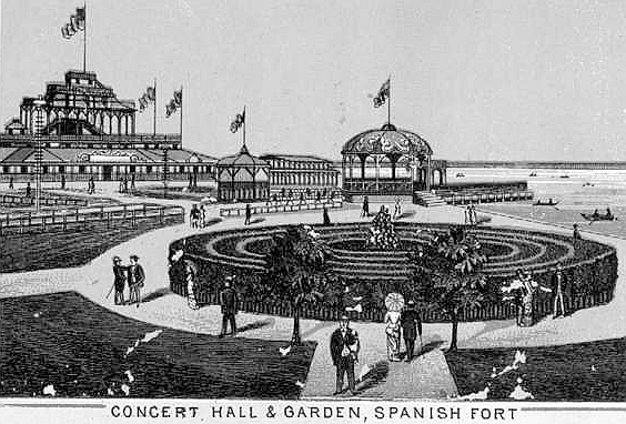
Elkins who developed it as a resort area he called "Spanish Fort". By the 1870s and early 1880s, the Pontchartrain Hotel was built as well as a large pavilion, casino, theater,
restaurants, gardens, an alligator pond, water pole matches, and bathing piers. It was called "The Coney Island
of the South" but it attracted luminaries such as Mark Twain ???????????????????????????
During the early 1923, the WPA land reclamation project signalled the end of Spanish Fort as an amusement haven.
Originally at Spanish Fort, Pontchartrain Beach moved to the what is now the University of New Orleans Technology Center at
Elysian Fields and the lake in 1928.
|