South boundary
of Tangipahoa Parish. Part of line dividing Isle of Orleans from Florida Parishes. Boundary between British West Florida and
Spanish Louisiana, 1763-1783; Spanish West Florida and French Louisiana., 1803; U.S. and Spanish West Florida, 1803-1810.
In 1699 Iberville reached Bayou Manchac via Mississippi River.
PASS MANCHAC LIGHT
Location: WEST SHORE OF LAKE PONTCHARTRAIN Station Established: 1837 Year
Current Tower(s) First Lit: 1868 Operational? NO Automated? YES 1952 Deactivated: 1987 Foundation Materials:
STONE Construction Materials: BRICK Tower Shape: CYLINDRICAL Markings/Pattern: WHITE Relationship to Other
Structure: ATTACHED Original Lens: FOURTH ORDER, FRESNEL 1859
In 1682, French explorer La Salle discovered the mouth of the Mississippi River by sailing down the river from
French settlements in the Great Lakes region. La Salle named the area near the river’s mouth Louisiana, after his king,
Louis XIV. A few years later, La Salle attempted to find the Mississippi from the Gulf, but ended up in Texas, and was assassinated
while trying to make it back to the river.
Under the direction of Jerome de Pontchartrain, minister of the Marine of France, a second expedition led by Pierre Le
Moyne Sieur d’Iberville was dispatched to locate the river in 1698. After finding the mouth and sailing upstream to
a point near present day Baton Rouge, Iberville was informed by local Indians about a backdoor route (Manchac in Choctaw)
to his ships, which were anchored in the Mississippi Sound near Biloxi. This shortcut led Iberville through a bayou, two lakes
and another bayou before reaching the sound. Iberville named the first and smaller of the two lakes Maurepas after Pontchartrain’s
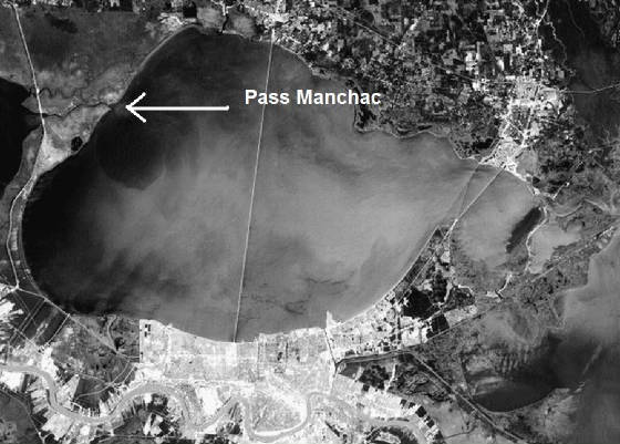
son, while the larger lake was named after Pontchartrain himself. Today, the winding, seven-mile-long waterway which links
the two lakes is known as Pass Manchac.
For the next two hundred years, ship captains used the lakes to reach Louisiana’s interior, avoiding the daunting
task of sailing upstream against the powerful Mississippi current. In 1837, the sum of $6,000 was allocated for building a
lighthouse at the northeastern end of Pass Manchac to mark this link between the lakes. A conical brick tower was constructed
by Francis D. Gott of New Orleans, and the first keeper, Isaac Zachary, received his appointment on January 16, 1839.
The first lighthouse was just one of four that have marked the pass. “Mud mortar” was used in the original
tower instead of lime and sand, and in just three years the tower was disintegrating and had to be rebuilt. Most of the material
in the tower could be reused in the second tower, and the construction bill came in at a low $1,630. The replacement tower
didn’t last much longer than the first. The lake encroached on the station, until the tower’s foundation was completely
submerged and the integrity of the tower was compromised.
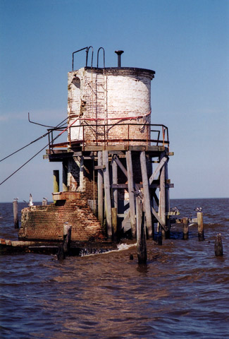
The third Pass Manchac Lighthouse was significantly different than the first two. The lighthouse, built using cypress trees
found abundantly in the nearby swamps, consisted of a two-story Victorian dwelling with a tower rising from its center. The
focal plane of the light was thirty-six feet above the lake. A tower based on the same design was later constructed at South Pass.
The third tower had the same problem as its predecessors: it was built too close to the shore. As the buffer zone between
the tower and the lake eroded away, the tower developed a lean. A breakwater was built around the lighthouse in a vain attempt
to save the structure. In 1855, the Lighthouse Board was forced to solicit funds for the construction of a fourth tower.
A construction site was selected two hundred feet northwest of the third lighthouse on a spot of ground that was not prone
to flooding. The lighthouse design called for a one-and-a-half story brick dwelling connected to a cylindrical tower of roughly
the same height. This cylindrical tower was the first and only one to be built along the Gulf Coast. A system of reflectors
was used in the tower upon its completion in 1857, until a fourth-order lens was provided in 1859. The lens was removed for
safe keeping by Confederates on September 18, 1861, as the Civil War affected the area.
The war was hard on the tower. Lighthouse Engineer Max Bozano reported that “as might be expected, there was all
possible damaged done, such as carrying away doors, windows, breaking the lantern glass by making a target of it”. The
lantern had to be replaced, but the lighthouse was repaired in less than two months and was back in service in January of
1867. The dwelling was home to the Succow family for over fifty years. Anthony Succow began his service as keeper in 1868.
His wife, Mary, took over in 1873, and she was followed by her son Hugo in 1909.
The lighthouse was automated in 1941, and stood empty for over a decade. Then, in 1952, the dwelling was razed to keep
out unwelcome occupants. At that time, the lighthouse sat on an island, no longer attached to the peninsula. The Coast Guard
abandoned the property in 1987, when the light was decommissioned. Without upkeep, the tower continued to deteriorate, and
would have been doomed had the Lake Maurepas Society not taken interest in the lighthouse in 1995. An offshoot of the society,
the Manchac Lighthouse Committee, was formed in 1999 to take responsibility for the structure.
Ben Taylor has served as president of the group, and successfully led an effort to have the lighthouse transferred from
the Coast Guard to the state. This move, transacted on December 28, 1999, allowed the committee to secure $230,000 of state
funding for restoration of the lighthouse. Using that sum, coupled with $16,000 raised by the group, a two-phase restoration
plan for the lighthouse was prepared. In phase one, the tower’s foundation was to be secured, and in phase two the tower
would receive a new foundation and be relit. Phase one began in 2002, when wooden pilings were driven around the tower, to
shore up its foundation and prevent it from toppling over. At that time, the lantern room was also removed from the tower
for restoration, but unfortunately it broke in two during the process.
The lighthouse committee, still armed with a significant sum of money, is currently rethinking its plan for the tower.
With the base of the tower submerged under several feet of water and given the towers pronounced lean, drastic measures will
be required to save it. As the tower is listed on the National Register of Historic Places, thoughts of moving the tower,
which would compromise the tower’s historical status, have previously been dismissed. However, given the precarious
condition of the tower, perhaps moving it ashore is the best way to preserve it. The tower would be more accessible to the
public, and the ever encroaching Lake Pontchartrain could be held at bay.
In April of 2003, the lighthouse was over a thousand feet from the nearest shore. It is hard to imagine that just a hundred
years earlier, Keeper Succow and his family maintained a garden and a small farm with chickens and cows next to the lighthouse.
see http://www.cr.nps.gov/MARITIME/light/manchac.htm
and http://www.lighthousefriends.com/light.asp?ID=809
The Illinois Central's Panama Limited at Pass Manchac north of New Orleans enroute to Chicago. In 1912, the IC renamed
its New Orleans to Chicago route in honor of the opening of the Panama Canal. A few years later, the Panama Limited became
an all-Pullman train - the luxury night train to Chicago. With a brief hiatus during the Depression, the Panama continued
to provide Chicago-New Orleans service (along with its sister train, the day time coach train The City of New Orleans)
until the late 1960s, when night service was discontinued.
[Photograph by Richard Dixon. General Interest Photograph Collection]


